1. The Invisible Asset - Why Traditional CMMS Falls Short on Location Intelligence
Leading manufacturers today rely on Computerised Maintenance Management Systems (CMMS) such as SAP PM, IBM Maximo and HxG EAM among many others to streamline maintenance operations by centralising information about physical assets and automating tasks. These platforms are indispensable database engines for tracking what happened, when it happened, and what will happen next. However, a critical deficiency exists when it comes to correctly answering the question of “where did it happen?”.
Why Location Deficit Exist in CMMS
The primary function of traditional CMMS software focuses on transaction recording and data normalisation, not spatial awareness. When these systems attempt to handle asset location, they typically rely on unstructured, free-text input fields. This design choice is the root cause of the location deficit. Technicians input subjective, shorthand, or inconsistent descriptors—such as "Near Boiler 3," "West Plant Room," or "Room 201 - East Side", or more often than now, this field remains empty . Because these locations are descriptive rather than quantitative, they are meaningless to spatial analysis tools and those new to working in the facility.
As a result of subjective free-text fields, these input fields become a liability, as subjective entries cannot be queried spatially, linked to geographic coordinates, or validated automatically against the physical reality. Without geospatially correct data, maintenance planners and technicians lack the visual map or contextual layer necessary to connect the abstract, digital work order to the physical location of the asset. In turn, preventing efficient task execution.
The Hidden Costs of Locational Ambiguity
Removing the ability to instantly locate assets translates directly into significant, measurable operational waste. The most critical and quantifiable cost is an increase in Mean Time To Repair (MTTR). When an alarm or work order is generated—especially during a critical breakdown—technicians must dedicate substantial time to physically searching for the correct asset, often relying on tribal knowledge, complex P&IDs not to scale, or inefficient directional communication. This "search time" is non-value-added waste that directly inflates MTTR and negatively impacts operational uptime.
Beyond emergencies, this ambiguity slows workforce efficiency and increases operational frustration. New hires, site contractors, or engineers performing system walk-downs rely on experienced personnel for escorting and guidance, consuming skilled labor hours unnecessarily.
The Strategic Gap of Data Integrity
The difference between the digital CMMS record and the physical reality on the floor leads to a lack of trust in the master asset register. If the location data is known to be inaccurate or inconsistent, whilst there are gaps in other areas of the asset data, confidence in the entire asset history and hierarchy can falter. This system inaccuracy undermines advanced Reliability-Centered Maintenance (RCM) activities, such as Failure Modes & Effects Analysis (FMEA) or Root Cause Analysis (RCA), which rely fundamentally on an accurate hierarchical structure of assets.
Geospatial / Asset Mapping Location Standard
Subjective, inconsistent, non-standardised, and non-queryable location data.
Coordinate-Based (XYZ Pinning)
Objective, precise, universally understood, and spatially queryable. Automatic association of room, building and level data.
Tells the worker what room or area (e.g., "Pump Room 3").
Visually guides the worker to the asset’s exact location. Tools like PlantQuest OneView also provide way-finding instructions and 3D views of the asset.
2. The Role of Spatial Context in Asset Management
To overcome the inherent limitations in your CMMS or asset hierarchy, manufacturers must adopt a dedicated layer of location intelligence. This shift involves exposing CMMS or asset data (work orders, asset hierarchy, asset metadata) into a visual, interactive overlay on the physical facility, providing intuitive spatial data.
Defining Location Intelligence for Maintenance
PlantQuest integrates existing systems—including CMMS, Building Management Systems (BMS), Building Information Modeling (BIM), and legacy layout drawings—to create a unified view of the site. The objective is to connect the Master Asset ID and its associated CMMS data to its precise real-world position, moving maintenance teams away from viewing disconnected lists and toward viewing integrated activities on an interactive map.
When asset data is ingested, initial location data (even if vague) can be used to roughly position and overlay the asset on the site's map. For example, if the room “CUB Boiler Room” is the location record against a pressure gauge in the CMMS, the pressure gauge will automatically be positioned in the center of the “CUB Boiler Room”. From there, using pin dropping tools on web or mobile applications, users refine the location to its exact XYZ coordinate, linking the digital record to a precise accurate location.
Harnessing Advanced Reality Capture
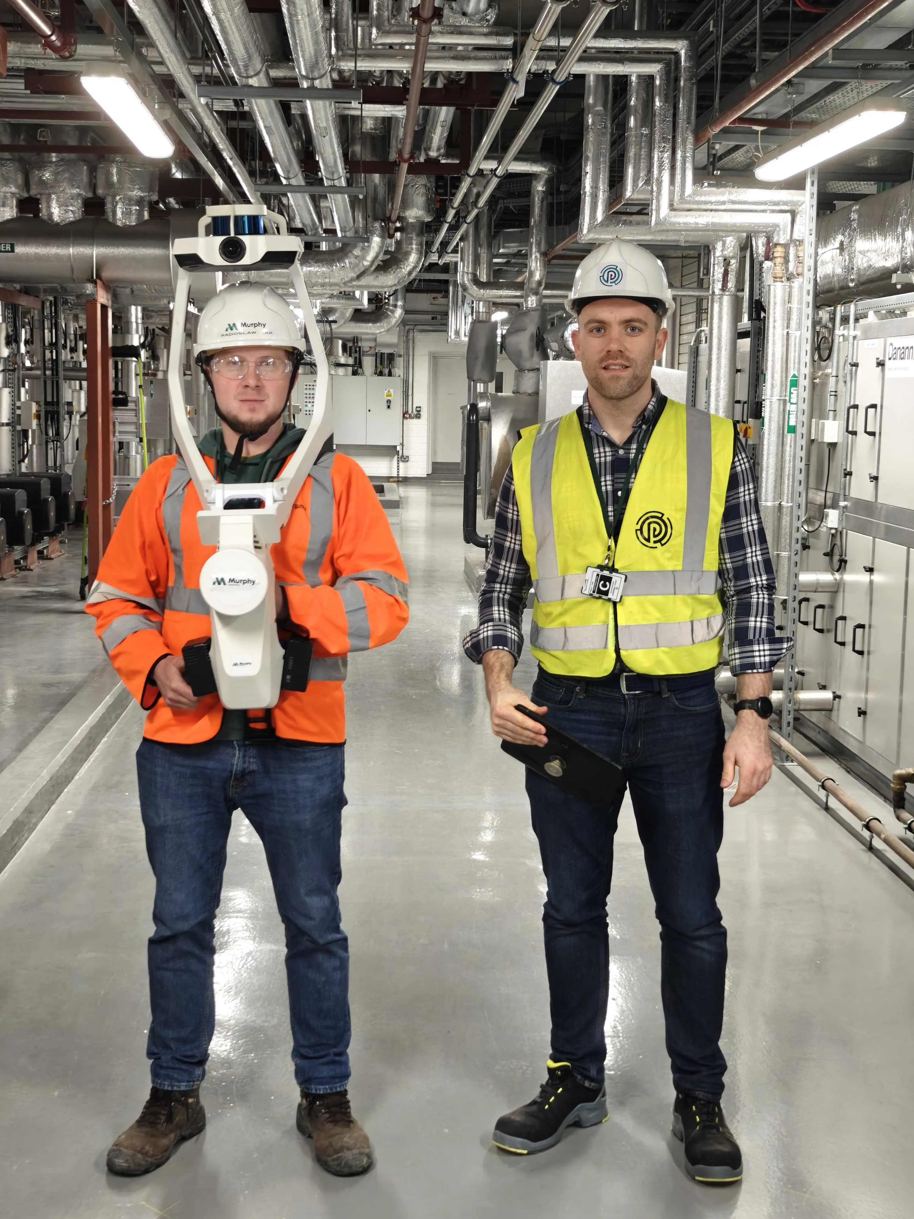
For full spatial intelligence, PlantQuest integrates with advanced reality capture technologies. This process leverages industrial-grade scanning, such as NavVis technology, which performs accurate laser scanning (LiDAR) of complex sites.
By unifying CMMS, BMS, and BIM data onto one common 3D platform, the solution removes traditional departmental information silos. The geospatial layer serves as the common operating language for the entire facility, where teams across maintenance, facilities, calibration and reliability uses the context for work planning and execution, engineering uses it for design review, and other departments, such as EHS, can use the confirmed visual context for compliance and safety activities.
3. Connecting CMMS Data to the Physical World
Achieving integration between spatial context systems and CMMS platforms (like SAP, Maximo, and EAMS among others) can be achieved in one of three ways:.
1-Direct Integration (API/Middleware) - Utilising open APIs, it is designed for immediate, high-fidelity data exchange, making it ideal for synchronising large amounts of data, such as real-time alarm notifications, new work order creation, or immediate status changes.
2-The Common Data Layer/Data Lake Strategy - This is recognised as the most robust, enterprise-grade solution, particularly for global manufacturers. Asset data is exported from the source CMMS into a centralised data lake or a Common Data Layer (CDL). The spatial platform then accesses this standardised layer. This method strategically decouples the CMMS from the visualisation system, mitigating the risk of version lock and enhancing data reusability.
3-CSV/Bulk Upload - For rapid initial onboarding, baselining, or integration with legacy or low-complexity EAMS where API connectivity is impractical, the simple transfer of master asset lists or work order data via CSV/Excel remains a vital option.
4. Asset Administration in PlantQuest
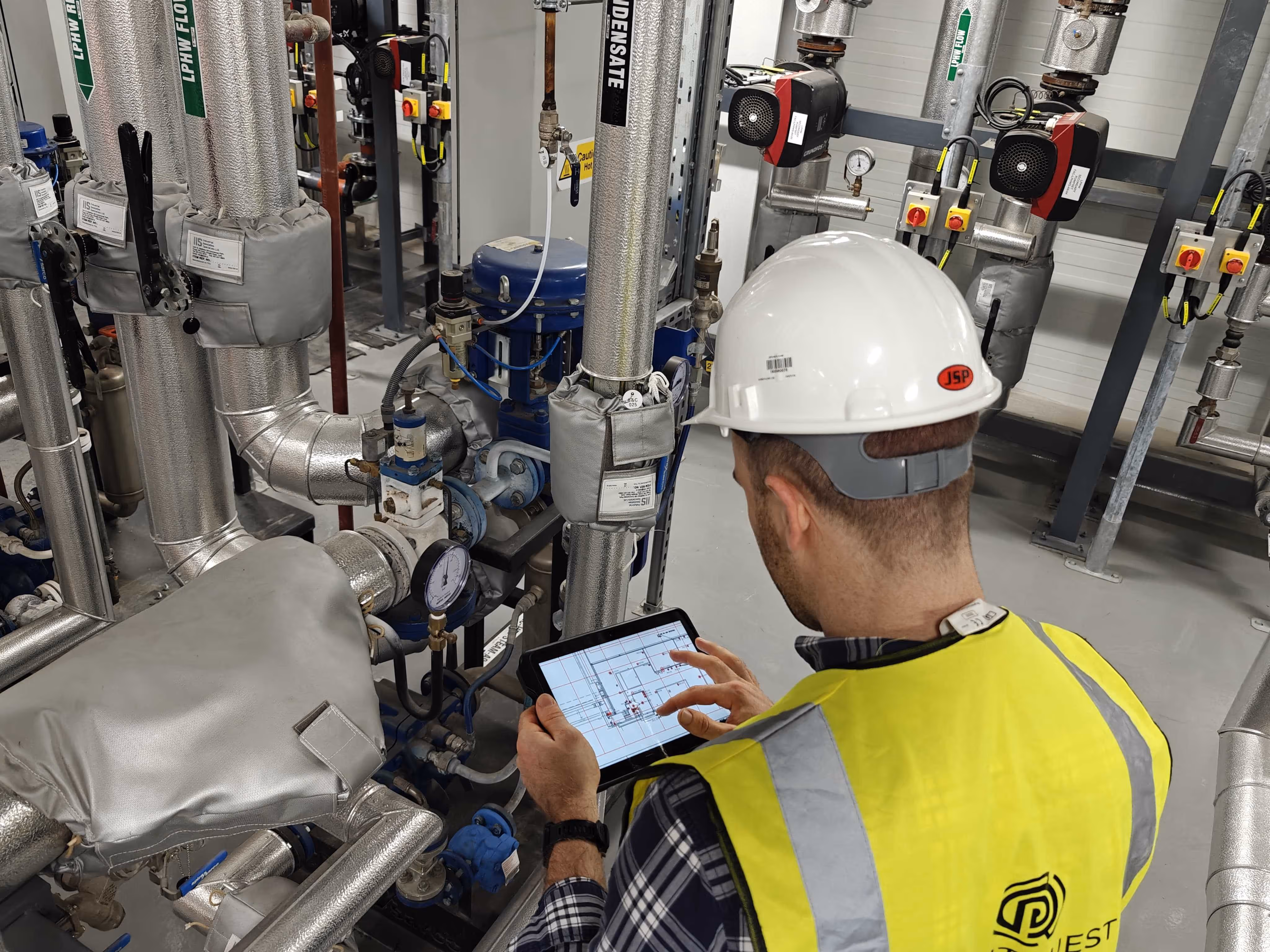
When initial asset information is imported, the assets are “orphaned” until a location is assigned. The primary function of the spatial system is then to leverage mobile tools—such as a tablet application— for technicians to physically locate (via pin drop), verify, and document the asset’s location in the field, capturing missing metadata and updating the asset register on the factory floor.
The Initial Capture
The capture process is built upon a philosophy of "Right-First-Time". Asset management teams use the digital field-based application to record asset locations and capture essential metadata, notes, and photos at the exact asset location. This methodology eliminates paper-based clipboards, minimises human error, and removes rework.
The interface (PlantQuest Capture) incorporates built-in validation rules that guide users step-by-step through required fields, enforcing consistency and completeness. This ensures that the data is accurate and complete during the capture process, resulting in a high-quality, georeferenced asset register. Recognising the realities of complex industrial sites, the application also operates in an offline mode, allowing technicians to capture and edit data in areas lacking internet connectivity. All data is automatically synced when connectivity returns, ensuring that productivity is maintained even in designated "dead zones".
Visualising and Verifying Asset Hierarchy
The PlantQuest platform mirrors the asset/parent-child hierarchy imported from the CMMS. By visually displaying this hierarchy directly on 2D maps and 360 scans, users can instantly understand the spatial and functional relationships between complex systems. For instance, the exact XYZ location of a pump component can be verified, which in turn verifies the integrity of the higher-level pump entity and the room location record. This approach ensures that the visual verification process feeds directly back into the quality and accuracy asset data.
5. Unlocking Operational Value: Quantifiable Benefits and Strategic Gains
The implementation of an asset mapping & visualisation platform like PlantQuest is not only a technical upgrade; it is a strategic investment with direct, quantifiable returns across maintenance, planning, and workforce management.
Accelerating Work Order Execution (W.O.E.)
By visualising all work orders, assets, and maintenance activities in the interactive 2D or 3D environments, maintenance planning teams gain unprecedented oversight. This visualisation allows for the creation of optimised, location-based work packs and the efficient scheduling and routing of maintenance technicians whilst this visual context eliminates operational delays. When a CMMS automatically generates a work order, that work order is immediately mapped and visible in PlantQuest. Workers are shown its exact location, way-finding directions and informed of access requirements helping them to execute the task more efficiently.
The MTTR Reduction Impact
The most critical operational impact is the optimisation of time. The ability to guide a worker via industrial indoor navigation algorithms to the exact location of a work order, breakdown, or alarm minimises the non-productive search time that plagues traditional maintenance environments.
This reduction in search time results in a significant increase in operational uptime. One medical device customer has reported a 40% reduction in Mean Time To Repair (MTTR) having mapped the location of assets within their MAXIMO CMMS system in PlantQuest. The efficiency gains extend beyond critical breakdowns into routine operations. The visualisation of the site’s assets, linked with the optimisation of system walk-downs and inspections, leads to demonstrable efficiency improvements in recurring tasks, achieving a reported 35% reduction in time spent on weekly maintenance tasks.
Optimising Training and Onboarding
In environments facing skilled labor shortages, PlantQuest acts as an essential workforce multiplier. The platform provides self-guided, intuitive indoor navigation which drastically reduces the need for experienced site personnel to escort new hires, contractors, or external auditors. New hires gain immediate access to complex site layouts and asset locations, significantly accelerating their site familiarity and operational readiness. This access to this context acts as a training tool, conceptually similar to how modern Augmented Reality (AR) or Virtual Reality (VR) solutions overlay digital instructions onto physical machinery for new technicians.
Case Studies
Leading manufacturers across pharmaceutical, biopharma and med-tech sectors are leveraging spatial context for strategic gains. In one biopharma facility, the integration of over 130,000 asset records from the site's SPA PM system provided end-to-end maintenance visibility, which led to optimised task planning and accelerated execution. Other projects have achieved substantial results, including a 75% reduction in alarm response times within a pharma production facility, showcasing the pervasive impact of location intelligence across all operational responses.
Mean Time To Repair (MTTR)
Time wasted locating failed assets/ breakdowns.
Guiding workers instantly to the exact location of the fault/WO.
Up to 40% reduction in MTTR.
Inefficient system walkdowns and task preparation.
Visual context, location-based work packs, optimised routing.
35% reduction in time spent on weekly tasks.
Workforce Onboarding/ Access
Experienced staff required to escort new hires/contractors.
Self-guided navigation and spatial orientation via the visual twin.
Removal of escort requirement, acceleration of site familiarity.
Data Integrity / Compliance
CMMS data incorrect or unverified against physical assets.
Digital, time-stamped audit trail and "Right-First-Time" verification.
Enhanced audit readiness and confidence in CMMS data integrity.
The traditional CMMS location deficit is a major impediment to operational efficiency and data quality within the manufacturing sector. Implementing a dedicated location intelligence layer to the CMMS and asset data provides location and data quality enrichment through flexible integration and harnesses the power of advanced visualisation (2D, 3D, and LiDAR visual twins). This integrated platform transforms CMMS and asset data from tabular data into a visual and usable operational tool.
By providing an asset verification process that uses guided field capture, and a robust digital audit trail, organisations secure verifiable data integrity. Crucially, this strategic investment yields measurable operational returns, including a demonstrated 40% reduction in MTTR and significant improvements in routine task efficiency, while simultaneously accelerating workforce onboarding and standardising asset management methodologies.